Randonnée Marche Vire Normandie - Rando « Granit Eau Bois 2012 »  - Photo

Rando « Granit Eau Bois 2012 »

 tracegps
tracegps

Utilisateur

© OpenStreetMap contributors
Longueur
Longueur
43 km
Altitude max
Altitude max
348 m
Dénivelé positif
Dénivelé positif
778 m
Km-Effort
Km-Effort  
53 km
Altitude min
Altitude min
108 m
Dénivelé négatif
Dénivelé négatif
695 m
Boucle
Boucle
Non
Date de création :
2014-12-10 00:00:00.0
Dernière modification :
2014-12-10 00:00:00.0

(0 Avis)

Marche
Marche
7h30
Difficulté : Très difficile

Scannez ce code QR pour ouvrir la randonnée dans l'application SityTrail

Application GPS de randonnée GRATUITE

Logo SityTrail SityTrail

IGN / Instituts géographiques

Télécharger SityTrail sur l'App Store Télécharger SityTrail sur Google Play

Logo SityTrail SityTrail World

Le monde est à vous

Télécharger SityTrail sur l'App Store Télécharger SityTrail sur Google Play Télécharger SityTrail sur Huawei AppGallery

À propos

Randonnée Marche de 43 km à découvrir à Normandie, Calvados, Vire Normandie. Cette randonnée est proposée par tracegps.

Description

Une randonnée début octobre. Je vous conseille vivement cette belle manifestation, en un mot PARFAIT A FAIRE ET REFAIRE. Visitez le site GRANIT EAU BOIS.

Profil altimétrique

Photos

Localisation

Pays :
France
Région :
Normandie
Département/Province :
Calvados
Commune :
Vire Normandie
Localité :
Vire
Départ:(Dec)
Départ:(UTM)
654984 ; 5412578 (30U) N.

Randonnées à proximité

Randonnée V.T.T. Vire Normandie - Rando VTT de Roullours - 2010 - Photo
V.T.T.
tracegps

V.T.T.

Moyen
(2)
Vire Normandie, Normandie, Calvados, France
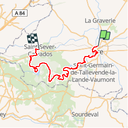
36 km | 44 km-effort
2h 15min
Oui
Randonnée A pied Vire Normandie - Le Moulin de Roullours - Photo
A pied
PRO

A pied

Facile
Vire Normandie, Normandie, Calvados, France
6 km | 7 km-effort
1h 35min
Oui
Randonnée A pied Vire Normandie - Le Domen de la Loge aux Sarrasins - Photo
A pied
PRO

A pied

Facile
Vire Normandie, Normandie, Calvados, France
14,1 km | 16,6 km-effort
3h 46min
Oui
Randonnée A pied Vire Normandie - Le Bois de l'Ermitage - Photo
A pied
PRO

A pied

Facile
Vire Normandie, Normandie, Calvados, France
3,1 km | 3,9 km-effort
53min
Non
Randonnée Cyclotourisme Vire Normandie - 12 - Vire Sourdeval - Photo
Cyclotourisme
Ceclm

Cyclotourisme

Moyen
Vire Normandie, Normandie, Calvados, France
24 km | 28 km-effort
Inconnu
Non
Randonnée Autre activité Vire Normandie - Basse Normandie - Ligne 440 - Vire - Romagny  - Photo
Autre activité
mich54

Autre activité

Très facile
Vire Normandie, Normandie, Calvados, France
39 km | 45 km-effort
5min
Non
Randonnée Vélo Vire Normandie - 2016-Vélofrancette n° 11 - Photo
Vélo
mimi53

Vélo

Moyen
Vire Normandie, Normandie, Calvados, France
36 km | 42 km-effort
2h 24min
Non
Randonnée Moto Vire Normandie - Suisse normande - Photo
Moto
brunopaci

Moto

Vire Normandie, Normandie, Calvados, France
164 km | 202 km-effort
3h 7min
Non
Randonnée V.T.C. Vire Normandie - Autour du débarquement - Photo
V.T.C.
famiski

V.T.C.

Très difficile
Vire Normandie, Normandie, Calvados, France
47 km | 56 km-effort
3h 44min
Non


Fermer
Mes abonnements